

 |
Jack Ganssle's Blog This is Jack's outlet for thoughts about designing and programming embedded systems. It's a complement to my bi-weekly newsletter The Embedded Muse.
Contact me at jack@ganssle.com. I'm an old-timer engineer who still finds the field endlessly fascinating (bio).
This is Jack's outlet for thoughts about designing and programming embedded systems. It's a complement to my bi-weekly newsletter The Embedded Muse.
Contact me at jack@ganssle.com. I'm an old-timer engineer who still finds the field endlessly fascinating (bio). |
Apollo 11 and Navigation
July 29, 2019
Bill Schweber always writes fascinating columns. With the recent anniversary of Apollo 11 he wrote an excellent article about how the astronauts navigated to the moon.
Did you know they used, in addition to other techniques, celestial navigation? A sextant, one that looked nothing like a marine sextant, helped these high-tech navigators determined their position by observing the stars.
For hundreds of years sailors have found their position while at sea via celestial. Until John Harrison's invention of the chronometer they could only determine latitude. Sans time, longitude is difficult to figure (there is an obscure method called lunar distances which few sailors mastered).
The idea is very simple, though implementation more complex. Suppose we could stop the Earth from rotating. Now observe the angle between the horizon and a celestial body, like the sun, moon, stars or planets. You're standing on an enormous circle; anyone on that circle would get the same angle. Walk closer where the body hovers over the Earth and the angle increases, strolling backwards decreases it. Now observe another body: where the two circles intersect is where you are (yes, they'll generally intersect at two places, but these rings are enormous; presumably you know which ocean you're in.
The circles' very vastness means that in your neighborhood you can approximate it as a straight line, which is called a "line of position," or LOP. Where the two (or more) LOPs intersect is your location.
It's inconvenient to stop the Earth's rotation; just advance the first LOP to the second knowing how fast and in which direction the ship is moving between observations.
Many other corrections are needed. The sextant will have some errors. Varying atmospheric pressure and temperature refracts the light from the body. Observe a body low on the horizon and the refraction is greater than if high as the image travels through a thicker atmosphere.
These calculations require ephemeris data: you need to know where the body in terms of celestial latitude (called "declination") and longitude ("hour angle" to navigators, or "right ascension" to astronomers). Every year there's a new Nautical Almanac issued, which is a book listing the position of all useful navigational bodies every hour of the year. These include the sun, moon, bright planets, and 57 stars (the data for the stars would be so vast they are given for every three days relative to a fictional point in the sky; that point's position is given for every hour). Interpolation tables help the navigator pin down their location to the second. For a four-second error puts you off by as much as a mile.
At sea, especially on a small boat which is being tossed around, you don't want to do a lot of spherical trig, so another book gives every solution to the "navigational triangle," which is formed by the closest pole (north or south), the boat's position, and the celestial body's declination and hour angle. These tables, too, require interpolation.
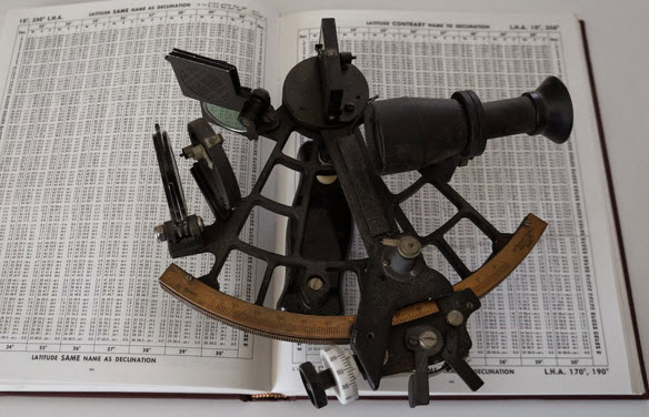
My sextant on the tables of solutions to the navigational triangle.
Finally, the sailor plots the LOPs on a chart. Now, at sea the distances are vast; the chart of the Northern North Atlantic covers thousands of miles. A pencil lead's width would prohibit getting an accurate position, so the navigator constructs mini-charts every few days on standard plotting sheets. The final position gets transferred to the big chart, traditionally at noon.
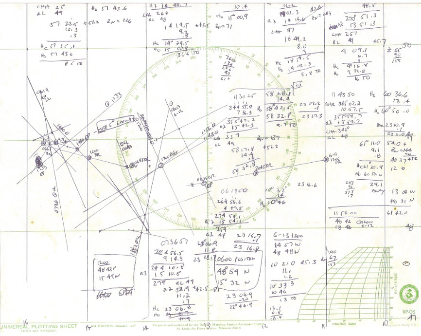
A plotting sheet for a few days on one of my Atlantic crossings on a 35-foot boat. The position is pretty far north and about 320 nautical miles west of Ireland.
In the real world celestial alone just isn't enough. Clouds can obscure the sky for days. So one is also plotting the dead reckoning position: your best estimate of where you've been over the last 24 hours based on the vessel's speed and course, factoring in current, if you know it, and leeway from the wind (which is an educated guess).
GPS will get you within meters. What about celestial? With practice a good navigator can get pretty close. At sea I can count on about two-mile accuracy in reasonable weather; when it's very rough that error balloons by two or three times.
Celestial is obsolete and practiced by only by the grizzled curmudgeons of the sea. On our sailboat we use GPS. But I always take some sextant sights, to stay in practice, and because it's fun. How cool to determine position using such old methods!
Feel free to email me with comments.
Back to Jack's blog index page.
If you'd like to post a comment without logging in, click in the "Name" box under "Or sign up with Disqus" and click on "I'd rather post as a guest."
Recent blog postings:
- Non Compos Mentis - Thoughts on dementia.
- Solution to the Automotive Chip Shortage - why use an MCU when a Core I7 would work?
- The WIRECARE - A nice circuit tester
- Marvelous Magnetic Machines - A cool book about making motors
- Over-Reliance on GPS - It's a great system but is a single point of failure
- Spies in Our Email - Email abuse from our trusted friends
- A Canticle for Leibowitz - One of my favorite books.
- A 72123 beats per minute heart rate - Is it possible?
- Networking Did Not Start With The IoT! - Despite what the marketing folks claim
- In-Circuit Emulators - Does anyone remember ICEs?
- My GP-8E Computer - About my first (working!) computer
- Humility - On The Death of Expertise and what this means for engineering
- On Checklists - Relying on memory is a fool's errand. Effective people use checklists.
- Why Does Software Cost So Much? - An exploration of this nagging question.
- Is the Future All Linux and Raspberry Pi? - Will we stop slinging bits and diddling registers?
- Will Coronavirus Spell the End of Open Offices - How can we continue to work in these sorts of conditions?
- Problems in Ramping Up Ventilator Production - It's not as easy as some think.
- Lessons from a Failure - what we can learn when a car wash goes wrong.
- Life in the Time of Coronavirus - how are you faring?
- Superintelligence - A review of Nick Bostrom's book on AI.
- A Lack of Forethought - Y2K redux
- How Projects Get Out of Control - Think requirements churn is only for software?
- 2019's Most Important Lesson. The 737 Max disasters should teach us one lesson.
- On Retiring - It's not quite that time, but slowing down makes sense. For me.
- On Discipline - The one thing I think many teams need...
- Data Seems to Have No Value - At least, that's the way people treat it.
- Apollo 11 and Navigation - In 1969 the astronauts used a sextant. Some of us still do.
- Definitions Part 2 - More fun definitions of embedded systems terms.
- Definitions - A list of (funny) definitions of embedded systems terms.
- On Meta-Politics - Where has thoughtful discourse gone?
- Millennials and Tools - It seems that many millennials are unable to fix anything.
- Crappy Tech Journalism - The trade press is suffering from so much cost-cutting that it does a poor job of educating engineers.
- Tech and Us - I worry that our technology is more than our human nature can manage.
- On Cataracts - Cataract surgery isn't as awful as it sounds.
- Can AI Replace Firmware - A thought: instead of writing code, is the future training AIs?
- Customer non-Support - How to tick off your customers in one easy lesson.
- Learn to Code in 3 Weeks! - Firmware is not simply about coding.
- We Shoot For The Moon - a new and interesting book about the Apollo moon program.
- On Expert Witness Work - Expert work is fascinating but can be quite the hassle.
- Married To The Team - Working in a team is a lot like marriage.
- Will We Ever Get Quantum Computers - Despite the hype, some feel quantum computing may never be practical.
- Apollo 11, The Movie - A review of a great new movie.
- Goto Considered Necessary - Edsger Dijkstra recants on his seminal paper
- GPS Will Fail - In April GPS will have its own Y2K problem. Unbelievable.
- LIDAR in Cars - Really? - Maybe there are better ideas.
- Why Did You Become an Engineer? - This is the best career ever.
- Software Process Improvement for Firmware - What goes on in an SPI audit?
- 50 Years of Ham Radio - 2019 marks 50 years of ham radio for me.
- Medical Device Lawsuits - They're on the rise, and firmware is part of the problem.
- A retrospective on 2018 - My marketing data for 2018, including web traffic and TEM information.
- Remembering Circuit Theory - Electronics is fun, and reviewing a textbook is pretty interesting.
- R vs D - Too many of us conflate research and development
- Engineer or Scientist? - Which are you? John Q. Public has a hard time telling the difference.
- A New, Low-Tech, Use for Computers - I never would have imagined this use for computers.
- NASA's Lost Software Engineering Lessons - Lessons learned, lessons lost.
- The Cost of Firmware - A Scary Story! - A hallowean story to terrify.
- A Review of First Man, the Movie - The book was great. The movie? Nope.
- A Review of The Overstory - One of the most remarkable novels I've read in a long time.
- What I Learned About Successful Consulting - Lessons learned about successful consulting.
- Low Power Mischief - Ultra-low power systems are trickier to design than most realize.
- Thoughts on Firmware Seminars - Better Firmware Faster resonates with a lot of people.
- On Evil - The Internet has brought the worst out in many.
- My Toothbrush has Modes - What! A lousy toothbrush has a UI?
- Review of SUNBURST and LUMINARY: An Apollo Memoir - A good book about the LM's code.
- Fun With Transmission Lines - Generating a step with no electronics.
- On N-Version Programming - Can we improve reliability through redundancy? Maybe not.
- On USB v. Bench Scopes - USB scopes are nice, but I'll stick with bench models.